Norseman
Norseman Project (Accent 100%)
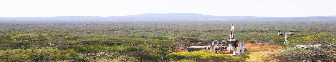
The Norseman project, comprising 5 Mining Leases and 8 Prospecting Licences covering an area of approximately 338 hectares, is located 5km south of Norseman in the Dundas Mineral Field. The project area occurs within a strongly mineralised portion of the southern Norseman‐Wiluna greenstone belt of the Yilgarn Craton.
The local geology consists predominantly of Archaean banded cherty siltstone / ironstone formations interbedded with mafic volcanics and intrusives. The ironstones, referred to as the Eastern and Western Banded Ironstones contain flanking volcanics and chert breccias, passing into fine clastics and magnetite ironstones.
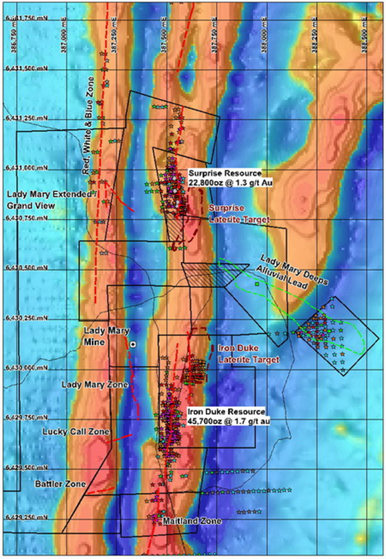
Gold mineralisation occurs predominantly along the Mt Henry Shear within the core of the Eastern Ironstone (Surprise – Iron Duke – Maitland/Break o’Day Trend) and along the eastern margin of the Western Ironstone (Lady Mary Trend). Additional mineralisation occurs in ENE-WSW trending cross‐cutting structures (Luck Call, Battler). The most significant mineralisation discovered to date consists of the north‐south trending Iron Duke (40,700oz @ 1.9 g/t Au) and Surprise (18,800oz @ 1.5 g/t Au) gold deposits along the Mt Henry Shear (99 percentile upper cut, 1.0 g/t Au lower cut off) (source: ASX announcement 26 November 2012). Over 70-80% of these resources are shallow, within 50m of surface.
During 2012/3 a comprehensive update of drilling data and a review of all geological data were completed. This was incorporated into a revised resource estimation and pit optimisation study of the Surprise - Iron Duke Resources to assess their potential and economic viability. The current gold resources are unlikely to support a stand-alone operation but represent opportunity for either a development joint venture or toll processing with local operators.
The work completed indicates that additional drilling is required to test potential for deeper repetitions of the stacked mineralisation. Drilling is also required to follow up newly identified zones, particularly near surface areas to the east of the main mineralised zone at Surprise Area Domain 2 and 4. The southern area of Iron Duke (Maitland zone) also has additional deep and along strike resource potential. Potential remains to also define additional mineralised surface laterites (< 8m depth) east of and in southern Surprise and north east of Iron Duke.
Future resource, geological validation and metallurgical drilling at Surprise – Iron Duke is recommended. Future work should include diamond drilling for metallurgical testwork and geological and resource validation that will improve interpretation and reduce risk related to earlier RC drilling. An improvement in the classification and the contained resources can be expected.
Tenements P70/1893 and 1904 covering the historically significant Lady Mary mine were acquired in 2012. The Lady Mary was the subject of sporadic mining since the early 1900’s with early reported production exceeding 26,000 oz at grades greater than 20g/t Au. Mineralisation is associated with the Lady Mary Shear and hosted by an east dipping northeast plunging quartz vein which occurs at the eastern contact of the Western Ironstone with gabbro. Proposed work includes review of geological information and construction of 3-dimensional model to accurately predict the plunge of the high grade Lady Mary shoot. This will utilize surveyed information, historical drilling and underground mine plans. Drilling of the untested but significantly mineralised structure south of the historic Lady Mary mine is also proposed.
Iron ore exploration has been authorized over P63/1380, 1381, 1383 and M63/225, 226, 247. Surface rock sampling has returned several promising results up 62.3% iron that require follow up.
Norseman Project – Locality Map with Resources at 0.5 g/t Au cutoff MAP
The Norseman project, comprising 5 Mining Leases and 8 Prospecting Licences covering an area of approximately 338 hectares, is located 5km south of Norseman in the Dundas Mineral Field. The project area occurs within a strongly mineralised portion of the southern Norseman‐Wiluna greenstone belt of the Yilgarn Craton.
The local geology consists predominantly of Archaean banded cherty siltstone / ironstone formations interbedded with mafic volcanics and intrusives. The ironstones, referred to as the Eastern and Western Banded Ironstones contain flanking volcanics and chert breccias, passing into fine clastics and magnetite ironstones.
Gold mineralisation occurs predominantly along the Mt Henry Shear within the core of the Eastern Ironstone (Surprise – Iron Duke – Maitland/Break o’Day Trend) and along the eastern margin of the Western Ironstone (Lady Mary Trend). Additional mineralisation occurs in ENE-WSW trending cross‐cutting structures (Luck Call, Battler). The most significant mineralisation discovered to date consists of the north‐south trending Iron Duke (40,700oz @ 1.9 g/t Au) and Surprise (18,800oz @ 1.5 g/t Au) gold deposits along the Mt Henry Shear (99 percentile upper cut, 1.0 g/t Au lower cut off) (source: ASX announcement 26 November 2012). Over 70-80% of these resources are shallow, within 50m of surface.
During 2012/3 a comprehensive update of drilling data and a review of all geological data were completed. This was incorporated into a revised resource estimation and pit optimisation study of the Surprise - Iron Duke Resources to assess their potential and economic viability. The current gold resources are unlikely to support a stand-alone operation but represent opportunity for either a development joint venture or toll processing with local operators.
The work completed indicates that additional drilling is required to test potential for deeper repetitions of the stacked mineralisation. Drilling is also required to follow up newly identified zones, particularly near surface areas to the east of the main mineralised zone at Surprise Area Domain 2 and 4. The southern area of Iron Duke (Maitland zone) also has additional deep and along strike resource potential. Potential remains to also define additional mineralised surface laterites (< 8m depth) east of and in southern Surprise and north east of Iron Duke.
Future resource, geological validation and metallurgical drilling at Surprise – Iron Duke is recommended. Future work should include diamond drilling for metallurgical testwork and geological and resource validation that will improve interpretation and reduce risk related to earlier RC drilling. An improvement in the classification and the contained resources can be expected.
Tenements P70/1893 and 1904 covering the historically significant Lady Mary mine were acquired in 2012. The Lady Mary was the subject of sporadic mining since the early 1900’s with early reported production exceeding 26,000 oz at grades greater than 20g/t Au. Mineralisation is associated with the Lady Mary Shear and hosted by an east dipping northeast plunging quartz vein which occurs at the eastern contact of the Western Ironstone with gabbro. Proposed work includes review of geological information and construction of 3-dimensional model to accurately predict the plunge of the high grade Lady Mary shoot. This will utilize surveyed information, historical drilling and underground mine plans. Drilling of the untested but significantly mineralised structure south of the historic Lady Mary mine is also proposed.
Iron ore exploration has been authorized over P63/1380, 1381, 1383 and M63/225, 226, 247. Surface rock sampling has returned several promising results up 62.3% iron that require follow up.
Norseman Project – Locality Map with Resources at 0.5 g/t Au cutoff MAP